So I'm back in Flagstaff again. Water is tenuous in the Sonora, and the desert is a very serious, desolate, vibrant, lovely, and lonely place. I suppose I am perhaps not "hard core" enough, but I ended up bailing to the town of Arivaca rather than finishing the leg connecting Nogales to Sasabe. The day started out great, I felt great, and it is beautiful out there. It was slow going because of the off-trail hiking and running over mountains and through valleys and canyons, but I was able to find water relatively often in the larger valley bottoms, and I often found myself using migrant trails to ease travel. However, after cresting the highest of the mountain ridges, I found myself looking down on a much drier and more rugged landscape. These lower elevation mountains were characterized by steep rocky cliffs and deep canyons- difficult terrain to move through. I chose a route that I thought best and seemed to follow the border relatively closely, and eventually ended up in large, steep-walled canyon. Though the canyon was generally headed west and water was very plentiful there, it took me approximately 2 hours to travel only about a mile as the crow flies when I actually likely traveled more like 6 miles due to the winding nature of the canyon. When I was able to leave the canyon out of another side canyon, I was traveling cross country again but without the benefit of migrant trails anymore, and the much drier landscape was not providing water where I was hoping to find it. As evening quickly approached, I headed north for some easier terrain, and found myself upon a Forest Service dirt road. I hiked into the night until I came to an intersection in the road. I had approximately 2.5 liters of water, and had to decide whether I would continue west toward Sasabe with the hope of finding water at one of the cattle tanks I had spotted using satellite imagery, or if I would head north on the Forest Service road toward Arivaca. It had taken me 13 hours to move 14 miles (as the crow flies), when I had realistically ran and hiked more than 35 miles. If it was going to be that difficult to move the remaining 20 miles or so to Sasabe, it was going to take me 2 more days. I only had enough food for 1 more day, and I had enough water to last me until maybe noon. So when I was eating "breakfast" and heard a truck coming down the road at 5:30am, I made the choice to flag him down and caught a ride back into Arivaca. In retrospect, I probably could have made it to Sasabe a little hungry but fine, but at the time I wasn't willing to take the risk.
I'm not done with BorderVenture despite the second setback. What I am opting to do instead, and what I think might be more productive in terms of telling the story properly, is to finish BorderVenture in pieces on the weekends. The next step will be to go to Sasabe, a place I've been told is a staging area for a lot of immigrants and has some issues with cartels, and just spend a day talking to people there. I will also look into setting up more caches for the 90 miles or so west of Sasabe, where water looks to be scarce, or potentially revising the route northward a bit to utilize some other roads. The following weekend would be running from Sasabe to Lukeville/Sonoyta, and the weekend after that would conclude BorderVenture by running from Lukeville/Sonoyta to Yuma. That's the plan right now, though plans don't seem to mean much of anything so far. Thanks for following along so far, and sorry for the let down and change in plans. Perhaps less epic this way, but hopefully a better way to tell the story (and perhaps a little easier for me to do so). I'll try to do another post soon about my time and experiences in the mountains west of Nogales.

Wednesday, March 23, 2011


Sunday, March 20, 2011
Back to the Border
Mostly healed up, made some shoe modifications, and headed back to the border now. Be sure to follow along via the SPOT beacon shared page (click on the SPOT image/link to the right to follow my location live), and I'll try to update the page whenever I can. Don't forget to "Like" the Facebook page (link also on the right)! Many thanks for the continued interest and support, and please share this with your friends!
Saturday, March 19, 2011
So what's in the pack???
I wish Border Patrol could just look at this for reference when I cross at the Ports of Entry! So here is what I've packed for BorderVenture- life on the run, in a backpack.

Read the picture like a book:
Backpack - Deuter 30L, pretty nice pack
Waterproof stuff sack
MSR 2L hydration bladder (2L of water in it)
Sleeping bag: 40 degree synthetic LaFuma bag
MSR 2L water bladder (with 1L of water in it)
(2) 0.6L water bottles (full, use these for electrolyte drinks)
SPOT beacon and carrying case
Toilet Paper
Sunscreen
(4) aluminum tent stakes and parachute-cord (In case I need to make a shelter)
Journal and pocket Spanish book (the book isn't very good, I don't really recommend it)
Katadyn water filter and water-purifying tablets
Electronics goodies on top of waterproof sack: iPod Touch, (4) AAA batteries, (2) AA batteries, Phone charger cord, camera and case, headphones (in case I'm losing my mind), Camera battery charger
To the right of the waterproof sack: lighter, sharpie marker, mechanical pencil, spork, toothpaste, Dr. Bronner's biodegradable soap
Adventure Medical Ultralight Waterproof kit
(1) pair synthetic underwear
(1) pair cotton underwear
(1) pair synthetic superlight weight long underwear (warmth at night)
(1) "Buff"- pretty neat thing, new to me, light and can make it into hat, headband, protection over face, etc
The ole wide-brimmed hat- an instant classic, great looks and great sun protection in a lightweight and breathable package
Lightweight waterproof tarp
Lightweight fleece jacket
Cotton t-shirt with custom "Hombre de Paz - BorderVenture" logo- having people sign this through the trip
(1) short sleeve synthetic running shirt
Teeny tiny running shorts
(3) pairs of socks
(1) pair of lightweight, synthetic hiking pants
(1) long sleeve synthetic running shirt
Missing from picture: GPS, iPod charger cord, cell phone, toothbrush, and food

All packed up with room to spare! It will actually be a little less full because I'll be wearing some of the clothes in there, and then the remaining space will be filled with food. I eat a lot.
 And there she is in business form. I wish I had a scale to weigh it, but I've cut down weight a good bit from what it was the first few days- dropped the rain jacket, a running hat, a warm hat, a couple small things I can't remember now, and a couple liters of water. Doing this a little smarter the second time around I hope. A true minimalist would probably laugh at this assemblage of items. The electronics certainly add a bit of weight, but I need them to document this properly, update along the way, and navigate (not that a GPS is necessary, but I don't have any good maps really, so this is the replacement). There are some other things I could drop, but I'm keeping them as (very small) measures of comfort and cleanliness. I don't want to be a total dirtbag when I'm trying to talk to or stay with people in border towns. Well, that's that. I'm still planning on starting again tomorrow morning- the achilles isn't quite 100% yet, but it is much better, and I think I've removed the original source of the problem by changing shoes.

Read the picture like a book:
Backpack - Deuter 30L, pretty nice pack
Waterproof stuff sack
MSR 2L hydration bladder (2L of water in it)
Sleeping bag: 40 degree synthetic LaFuma bag
MSR 2L water bladder (with 1L of water in it)
(2) 0.6L water bottles (full, use these for electrolyte drinks)
SPOT beacon and carrying case
Toilet Paper
Sunscreen
(4) aluminum tent stakes and parachute-cord (In case I need to make a shelter)
Journal and pocket Spanish book (the book isn't very good, I don't really recommend it)
Katadyn water filter and water-purifying tablets
Electronics goodies on top of waterproof sack: iPod Touch, (4) AAA batteries, (2) AA batteries, Phone charger cord, camera and case, headphones (in case I'm losing my mind), Camera battery charger
To the right of the waterproof sack: lighter, sharpie marker, mechanical pencil, spork, toothpaste, Dr. Bronner's biodegradable soap
Adventure Medical Ultralight Waterproof kit
(1) pair synthetic underwear
(1) pair cotton underwear
(1) pair synthetic superlight weight long underwear (warmth at night)
(1) "Buff"- pretty neat thing, new to me, light and can make it into hat, headband, protection over face, etc
The ole wide-brimmed hat- an instant classic, great looks and great sun protection in a lightweight and breathable package
Lightweight waterproof tarp
Lightweight fleece jacket
Cotton t-shirt with custom "Hombre de Paz - BorderVenture" logo- having people sign this through the trip
(1) short sleeve synthetic running shirt
Teeny tiny running shorts
(3) pairs of socks
(1) pair of lightweight, synthetic hiking pants
(1) long sleeve synthetic running shirt
Missing from picture: GPS, iPod charger cord, cell phone, toothbrush, and food

All packed up with room to spare! It will actually be a little less full because I'll be wearing some of the clothes in there, and then the remaining space will be filled with food. I eat a lot.

Thursday, March 17, 2011
A Picture Post

Frantic preparations wreaked a bit of havoc on the room...

Day 2 of BorderVenture (no pictures from Day 1 because the camera got a bunch of sand in it and wouldn't work). I was staring at that mountain range for most of the day (the southern end of the Huachuca's, I believe), knowing that I would eventually have to go through them.

A transition in the wall material and construction, getting closer to the San Pedro River

Finally arrived at the San Pedro River. It was a distant green band through a much drier landscape for quite a while. Thankfully they only extended vehicle barriers through the riparian area rather than the full wall. Not that the wall would have been able to stand for very long in the river without some serious engineering anyway.

Though it may appear to be a small stream to anyone coming from a place that has water, this is certainly a river by Sonoran standards, and I'm sure is quite impressive when a monsoon storm unleashes. I spent a good 30 minutes here, not wanting to leave the shade of the mesquite and cottonwood trees and the cool water.

A beautiful landscape to behold on the other side

And behold the sweet irony of the border wall. If for some reason you couldn't climb it (damn near anyone could), you can just walk right around it- though you might have to lift your leg about knee height here. Finally getting into the mountains here, where it likely became too difficult and expensive to continue the wall. Shortly after this the vehicle barrier stopped and the border was demarcated only by a barbed wire fence.

Just a particularly pretty tree on the mountainside.

A small barricade built under a tree, likely used by both migrants and drug smugglers to hide from observers in helicopters. I saw many of these scattered all over the mountainside, under trees, in washes, under large boulders, etc. Often there were many water bottles, miscellaneous other containers, clothing, and other items left behind by people passing through.

After bailing down off the side of the first mountain to get water from a horse pasture in Mexico, I found myself onto what was obviously a migrant path. I walked for a couple more hours through dusk and into the night, and eventually came upon this memorial to some who had died attempting to cross the desert. The candles inside were all lit, and near the memorial there was over a hundred spent candles. Someone still cares greatly for these people- this was as close to the middle of nowhere as you can get these days. The border militarization is killing people.

Day 3 of BorderVenture. No more wall, just vehicle barriers and fencing. Many fewer Border Patrol agents in this region, only saw three the entire day. This was a very large basin of high elevation prairie. Quite beautiful, though a little hot and dry.

Rolling hills, open prairie, big trees and draws, isolation, and achilles pain were the name of the game this day.

Some of the biggest Cottonwood trees I've ever seen, just inside the "town" of Lochiel. It was a Port of Entry until about 30 years ago, and my guess is that it had a little more traffic and people back in those days. I didn't see anyone when I passed the dozen or so homes collected there, but it was obvious that people still live there. I can't tell you how isolated this place is. The nearest town is Nogales, connected by about a 40 mile dirt road that crosses through a rugged mountain range.

A view of Nogales from the family's house I stayed at for two evenings. I crossed the mountains on the Mexican side of the border because there was a "highway" (dirt road) that allowed more direct and easy travel than bushwhacking my way there, but I ended up hitchhiking the last 15 or so miles to town due to achilles pain. The fourth person to pass picked me up, and refused to take any money when they stopped. They certainly wouldn't have had similar experience were they in my situation on the U.S. side of the border, even if they were legal citizens. I was overwhelmed by kindness while in Nogales.
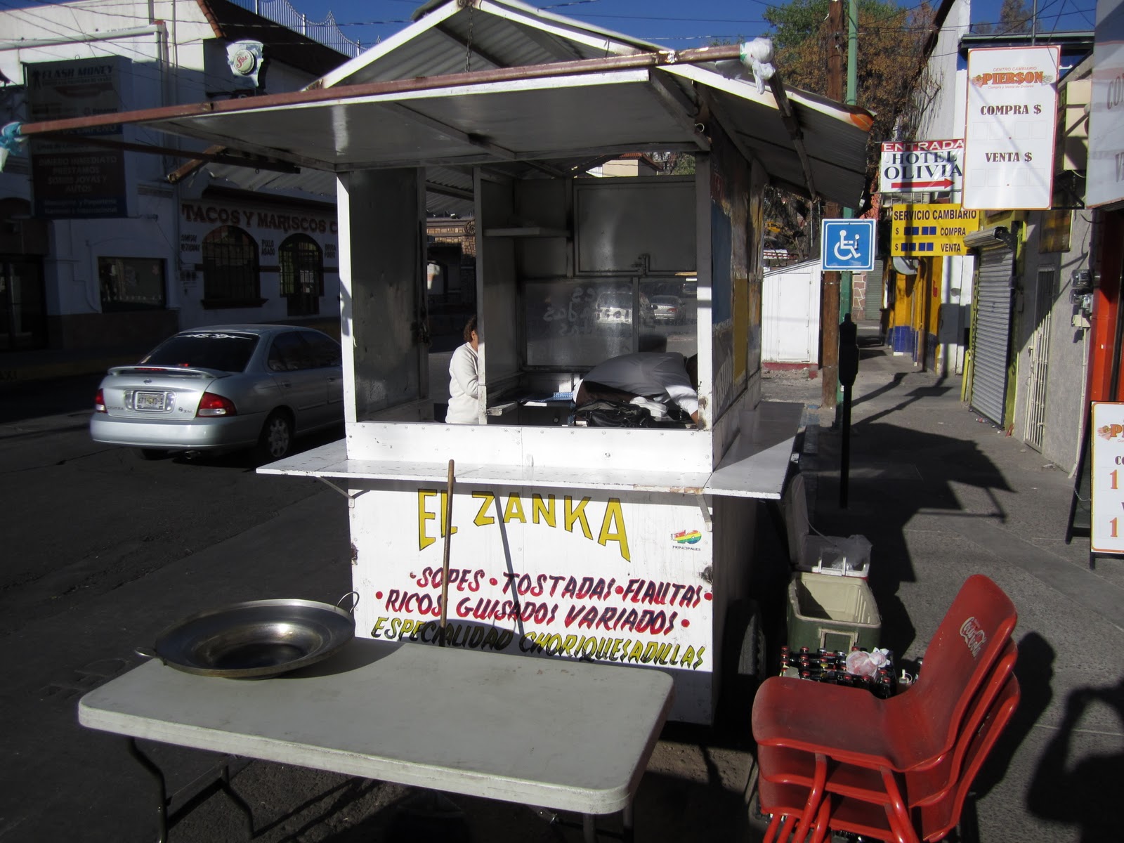
El Zanka, the street cart run by Rosie and her family. If you're ever in Nogales, make sure to stop by and order one of the legendary Choriquesadillas. They are only a few blocks south of the Port of Entry, but most of their business seems to come from locals working in the area. Since the border became so much more of a hassle to cross and gross exaggerations of violence were echoed through the U.S. media, the businesses here get little of the tourism that many had come to depend on for income.
Wednesday, March 16, 2011
Minor Setback
I've decided I need to take a few days off. I started walking out Nogales around 5am, and after walking for a couple hours, the pain in my right achilles tendon is as bad or worse than before. I am quite torn about this decision, but I called and talked with a good friend, and what he said echoed the more sensible and logical parts of my conscience. It might have been fine to keep going, but the next two days to Sasabe are the most rugged of the trip and very remote- through desert mountains and canyons without roads or trails. So the two items of concern are 1) it becoming a more serious injury that might require rescue, and 2) It is making me move more slowly and awkwardly, increasing the likelihood of other injuries and overuse due to overcompensation, and 3) it is making me take longer to get to water sources. Water sources that might not be there at all. So there's the rub. And I'm pretty sure it is literally rubbing causing my injury, the back of the shoe rubbing on my achilles where it attaches to the heel. It is a newbie mistake to start a long hike with new shoes, but I was hoping it would be fine because I've never had foot or achilles problems, and I love my old pair of Salomon's. But these are a different model, and apparently don't fit quite the same way. So here I sit, typing in Tucson. When I can get my car keys back tomorrow I'll drive to Flagstaff and either grab a different pair of shoes or buy something entirely different. Best case scenario, I'll be back on the border by Saturday, but it may take longer. Sorry for the let down. If I could do it any other way I certainly would.
Tuesday, March 15, 2011
Rough Start
So I started BorderVenture with a mild cold and possibly a sinus infection. Likely a side-effect of the long days, little sleep, and the stress of preparing for the venture. It made the 23ish miles from Douglas/Agua Prieta feel very long, and it certainly took longer than expected. I took with me a pocket Spanish book, so I´ve been working on my Español a bit when the walking is easy, and I did a fair bit of that on the first day. I definitely didn´t drink or eat enough my first day, and not really for any good reason other than that I knew I could buy a big meal at the end of the day.
The border wall is continuous from Douglas all the way to the mountains about 15 miles west of Naco, making approximately 40 miles of wasted resources. An enormous amount of resources. The wall through there is secured in the ground by cement, and varies in form from 18ft tall round steel poles to solid steel and heavy-gauge mesh panels. One bonus of the wall is that it provides great shade if you´re walking on the U.S. side. If this wall was truly built with the intent to stop people, it utterly fails. I could easily climb over the wall in most places, and saw tracks in the dirt demonstrating that others had already done so that day. Some research is being done as to who received the government contracts to build a lot of the wall, and apparently its some of the same companies building the apartheid wall in Israel. Great people, eh? Someone made a lot of money off of this wall.
On the other side of those mountains, the border wall becomes 30 miles of vehicle barrier (look like tank traps, appear to be made from old railroad tracks) and a 5-strand barbed wire fence. Basically not stopping anyone, in fact, I crossed it myself several times. Border Patrol is also much more dispersed here, although there are still around 300 agents (number given by a Border Patrol agent) working in the large basin region between the two mountain ranges west of Naco and east of Nogales.
Enough about that, more about the rough start. Like I said, started with a sinus infection. Toward the end of the first day I developed some mild pain in my right achilles tendon. Could be overuse from running and hiking with a heavy pack, could be the new shoes I´ve only worn once before begining BorderVenture, could be something else entirely. The second day went slowly also because I started late (because of an interview with the Sierra Vista Herald), because my achilles hurt, and because I had to carry a lot more water. I´m trying to be self-sufficient with water, but I´ve needed to drink a lot more than I was hoping to need, making me dependent on water sources that can´t be depended upon (water is tenuous at best in the desert). This is an unfortunate turn of events, and could make upcoming sections of the journey much more difficult than I was expecting. No reason to worry for me, I´m not going to endanger myself, but it is just going to be harder. And thats with the assumption that my achilles injury will heal itself or can be ignored. Right now I have a healthy portion of pain just walking around town, and because of the achilles pain I ashamedly ended up hitchhiking the last 15 miles into Nogales yesterday . In Mexico. Kind of ironic that only the fourth Mexicano truck to pass stopped an picked up a Gringo just south of the border, no questions asked. A Mexicano certainly wouldn´t get the same treatment just north of the border.
I think that is all I have time for now, I´ll try to post again soon about some of my experiences and the poeple I´ve met, but I just wanted to give an update where things are at the moment.
The border wall is continuous from Douglas all the way to the mountains about 15 miles west of Naco, making approximately 40 miles of wasted resources. An enormous amount of resources. The wall through there is secured in the ground by cement, and varies in form from 18ft tall round steel poles to solid steel and heavy-gauge mesh panels. One bonus of the wall is that it provides great shade if you´re walking on the U.S. side. If this wall was truly built with the intent to stop people, it utterly fails. I could easily climb over the wall in most places, and saw tracks in the dirt demonstrating that others had already done so that day. Some research is being done as to who received the government contracts to build a lot of the wall, and apparently its some of the same companies building the apartheid wall in Israel. Great people, eh? Someone made a lot of money off of this wall.
On the other side of those mountains, the border wall becomes 30 miles of vehicle barrier (look like tank traps, appear to be made from old railroad tracks) and a 5-strand barbed wire fence. Basically not stopping anyone, in fact, I crossed it myself several times. Border Patrol is also much more dispersed here, although there are still around 300 agents (number given by a Border Patrol agent) working in the large basin region between the two mountain ranges west of Naco and east of Nogales.
Enough about that, more about the rough start. Like I said, started with a sinus infection. Toward the end of the first day I developed some mild pain in my right achilles tendon. Could be overuse from running and hiking with a heavy pack, could be the new shoes I´ve only worn once before begining BorderVenture, could be something else entirely. The second day went slowly also because I started late (because of an interview with the Sierra Vista Herald), because my achilles hurt, and because I had to carry a lot more water. I´m trying to be self-sufficient with water, but I´ve needed to drink a lot more than I was hoping to need, making me dependent on water sources that can´t be depended upon (water is tenuous at best in the desert). This is an unfortunate turn of events, and could make upcoming sections of the journey much more difficult than I was expecting. No reason to worry for me, I´m not going to endanger myself, but it is just going to be harder. And thats with the assumption that my achilles injury will heal itself or can be ignored. Right now I have a healthy portion of pain just walking around town, and because of the achilles pain I ashamedly ended up hitchhiking the last 15 miles into Nogales yesterday . In Mexico. Kind of ironic that only the fourth Mexicano truck to pass stopped an picked up a Gringo just south of the border, no questions asked. A Mexicano certainly wouldn´t get the same treatment just north of the border.
I think that is all I have time for now, I´ll try to post again soon about some of my experiences and the poeple I´ve met, but I just wanted to give an update where things are at the moment.
Subscribe to:
Posts (Atom)